Best GPS Units for Boats: Reliable Marine Navigation for 2026
Finding the right GPS unit for boats involves balancing rugged construction, display clarity, and dependable navigation features. The following selections emphasize marine-grade reliability, offshore satellite tracking, and user-friendly interfaces. Read on to compare five top Garmin models designed to keep you oriented on the water, from coastal chartplotters to handhelds with floating designs. The buying guide at the end highlights key factors to consider across different boating styles and use cases.
| Product | Brand | Key Feature |
|---|---|---|
| Garmin eTrex 22x | Garmin | 2.2” color display with topo maps and routable roads |
| Garmin GPSMAP 79s | Garmin | Rugged, floating handheld with worldwide basemap |
| Garmin GPS 73 | Garmin | Marine features, long battery life, sailing aids |
| Garmin ECHOMAP UHD2 54CV | Garmin | 5” display with CHIRP traditional and ClearVü sonars |
| Garmin ECHOMAP UHD2 94sv | Garmin | 9″ touchscreen with GT56 transducer and Navionics+ coastal charts |
Garmin eTrex 22x: Rugged Handheld GPS Navigator

The Garmin eTrex 22x is designed for versatile outdoor use, including marine contexts where a compact, durable handheld is valuable. Its 2.2-inch sunlight-readable color display provides legible mapping even in bright sun. Preloaded Topo Active maps with routable roads and trails support cycling and hiking, making this unit adaptable for shore excursions and backcountry routes. While not a full chartplotter, the device excels as a reliable backup navigator with easy waypoint management and GPS/GLONASS satellite reception for dependable performance in coastal areas.
Garmin GPSMAP 79s: Floating Marine Handheld

The GPSMAP 79s is a rugged, floating handheld built for marine environments. It features a high-resolution color display with scratch-resistant glass and expands memory to store up to 10,000 waypoints, 250 routes, and 300 activities. The device supports multiple satellite constellations, including GPS, GLONASS, Beidou, Galileo, and more, providing reliable global tracking and navigation. Its floating design helps mitigate loss at sea, while IPX-rated water resistance adds a layer of protection during splashes or spray.
Garmin GPS 73: Marine Navigator
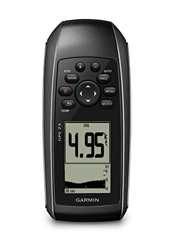
The Garmin GPS 73 focuses on sailing and coastal navigation with built-in SailAssist features, including a virtual starting line, countdown timers, and tack assist. It also provides long battery life, operating for 18+ hours on two AA batteries. Marine-oriented functions cover MOB, off-course alerts, anchor drag warnings, and route planning. This handheld device offers a balanced blend of sailing-centric tools and reliable map navigation for boaters who want dedicated sailing features in a compact form.
Garmin ECHOMAP UHD2 54CV: 5″ Chartplotter

The ECHOMAP UHD2 54CV provides a compact 5-inch chartplotter with dual-view sonar options. It supports CHIRP traditional and ClearVü scanning sonars for detailed bottom views and fish targets. High-contrast color palettes enhance water visibility, and the device can be used with preloaded coastal maps—helpful for nearshore navigation and fishing-focused boating. This model suits smaller boats that require dependable chartplotting and sonar capabilities without a larger display footprint.
Garmin ECHOMAP UHD2 94sv: 9″ Touchscreen Chartplotter

The ECHOMAP UHD2 94sv delivers a large 9-inch touchscreen with a bright display and precise navigation. It includes the GT56 transducer for traditional CHIRP sonar, ClearVü, and SideVü scanning, offering detailed bottom imagery and fish detection. Built-in Navionics+ coastal charts provide extensive coastal coverage, making this chartplotter ideal for larger boats and offshore trips where comprehensive chart detail and sonar clarity are critical. A robust option for serious anglers and coastal voyagers alike.
Buying Guide: Key Purchase Considerations
- Display size and readability: Larger screens improve map readability and sonar views, especially in bright sunlight. Choose a size that fits your helm space and line of sight.
- Sonar and charting capabilities: If fishing is a priority, models with CHIRP, ClearVü, and SideVü provide better bottom detail. For coastal navigation, built-in Navionics+ or preloaded coastal charts are valuable.
- Power and durability: Marine environments demand water resistance, floating capabilities for handhelds, and long battery life for handheld units. Consider IP ratings and battery options for extended trips.
- Networking and integration: Chartplotters that integrate with other devices, radar, and AIS systems offer enhanced situational awareness. Some handhelds can share data with other Garmin devices via wireless connectivity.
- Portability vs. fixed installation: Handheld options like the eTrex 22x and GPSMAP 79s are versatile backups or supplemental tools, while fixed-mount chartplotters like the UHD2 series provide comprehensive, always-on navigation at the helm.
- Update and map access: Free lifetime map updates and access to current marine data improve route planning and safety alerts. Verify update policies for the model you choose.
- Ease of use: Look for sailing aids (e.g., tack assist, virtual starting lines) and intuitive menus that reduce distraction while navigating on the water.
When selecting a GPS unit for boating, consider your vessel size, typical voyage length, and whether you need backup navigation or full-time chartplotting on deck. The five models above cover a spectrum from portable handheld devices to full-featured chartplotters, helping you tailor a solution to your navigation style.