Best Online Marine Chart Plotter Options for Accurate Navigation
Finding the right online marine chart plotter helps sailors and students plot courses precisely when GPS or electronics are limited. This guide highlights five top plotting tools suited for coastal cruising, training, and exam preparation. Each option is explained with who it’s best for, why it’s chosen, and a practical limitation to consider. The summary table below quickly compares core aspects to aid quick decisions.
| Product | Best For | Key Strength | Notes |
|---|---|---|---|
| Weems & Plath Marine Navigation Parallel Plotter | Traditional navigators and students | Durable, multiple scales for U.S. charts | Solid aluminum roller assembly |
| Liquidraw Portland Course Plotter with Marine Protractor | Coastal cruisers and training crews | All-in-one tool with protractor and dividers | Clear acrylic with bold markings |
| Marine Cartography Compatible With Chart Plotters (Pacific Islands SD Card) | Garmin/Navionics users and chart card fans | Pacific coverage and easy card integration | SD/Micro-SD format |
| Mariners Chart Plotting Tool Kit (Weems & Plath style) | Students and exam prep | Complete plotting toolkit | Includes multiple accessories |
| Brilluxa Station Pointer | Three-point positioning on nautical charts | Three-bar locator with adjustable benchmarks | Specialized three-marker setup |
Weems & Plath Parallel Plotter

The Weems & Plath Parallel Plotter is a durable acrylic tool mounted on a marine-grade aluminum roller assembly. It includes distance scales at 1:20,000, 1:40,000, and 1:80,000 to fit U.S. Coast and Harbor Charts, plus inch and nautical mile scales. Best for traditional navigators and students who favor a robust, long-lasting plotting aid and straightforward scale transfer. A potential limitation is that it relies on manual chart work without integrated digital features.
Liquidraw Portland Course Plotter with Protractor
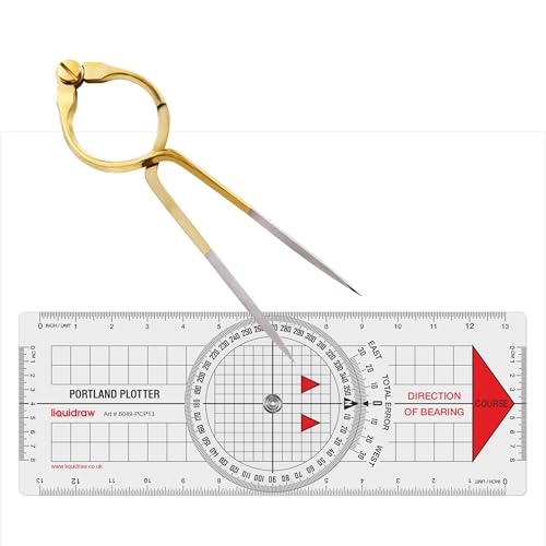
This all-in-one marine navigation set combines a Portland course plotter with a built-in protractor and an 8″ single-handed brass divider. It is ideal for coastal cruising, yacht sailing, and training scenarios where transferring bearings and measuring distances on paper charts is essential. Made from durable transparent acrylic with bold scale markings, the brass divider offers smooth, precise measuring. Choose this if you want an integrated plotting and measuring tool in a single kit. A caveat is that the kit is paper-chart focused and may require careful handling to prevent wear on the markings.
Marine Cartography for Chart Plotters (Pacific Islands SD Card)

This chart-card-based option covers detailed Pacific Ocean island data and uses standard SD or Micro-SD card formats. It is best for users who work with Garmin Navionics+ or similar systems and want straightforward chart data access for marine navigation. Its limitation is reliance on card data for updates and compatibility with specific plotter ecosystems.
Mariners Chart Plotting Tool Kit

The Mariners Chart Plotting Tool Kit offers a complete set for traditional plotting when GPS is unavailable or unreliable. It includes a premium 12″ parallel ruler, dividers, pencils, eraser, sharpener, notepad, calculator, and magnifier. Best for maritime students and exam preparation, providing a comprehensive suite for accurate chart work. A limitation is that it emphasizes traditional tools and may lack digital compatibility for modern workflows.
Brilluxa Station Pointer
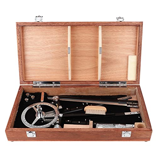
The Brilluxa Station Pointer is a three-arm positioning tool designed for nautical charts with copper dials and movable benchmarks. It supports three-mark two-corner positioning to determine ship position and ensure safe passage. Best for navigators who require a fixed three-point reference for chart work. A potential limitation is its specialized function, which may not replace other plotting tools for every charting style.
Buying Guide: Key Considerations for Online Marine Chart Plotters
- Purpose and environment: Are you chart plotting on paper charts, or do you need compatibility with digital chart cards and plotters?
- Chart scale coverage: Do scales suit your typical charting region (coastal, harbor, or open water)?
- Durability and materials: Do you need lightweight acrylic, or a robust metal roller system for frequent use?
- Toolkit completeness: Do you require an all-in-one kit with protractor, dividers, and pencils, or a focused plotting tool?
- Ease of use: Are clear markings and legible scales more important than advanced digital features?
- Compatibility: If using SD cards or specific chart ecosystems, verify format and device compatibility.
Frequently Asked Questions
- What is a marine chart plotter best used for?
It is used to transfer routes and bearings from nautical charts to determine a vessel’s path on paper charts or in simple hand plotting workflows.
- Do I need digital chart cards for plotting tools?
Not always. Traditional plotting tools work well for paper charts, training, and certification tests, while digital options complement electronic navigation systems.
- Which tool is best for beginners?
A complete plotting toolkit with clear scales and easy-to-read markings is best for beginners and exam prep.
- Can these tools be used for aviation plotting?
Some tools are designed specifically for aviation charts and WAC sections, while others are strictly marine. Check the product description for intended use.
- Are these plotting tools durable for field use?
Many are built with acrylic or brass components and durable frames; however, heavier metal assemblies may be preferred for frequent, rugged use.
- How do I choose between paper-chart plotting and digital plotting?
Consider your typical voyage, required accuracy, training needs, and whether you rely on paper charts, electronic charts, or both.