Best Marine Chartplotters &Amp; GPS for Rugged Water Navigation
The top picks below are designed for serious boaters who need reliable marine chartplotting, precise waypoints, and durable hardware. This guide highlights five Bluetooth- and satellite-ready options best for coastal anglers, freshwater sailors, and sea-going mariners who value floatation, global tracking, and built‑in charts. Each product section explains who it’s best for, why it was selected, and a practical caveat.
Choosing at a glance
| Product | Key Benefit | Best For |
|---|---|---|
| Garmin GPSMAP 79sc | Rugged, floating handheld with BlueChart g3 coastal charts | Mariners needing a floating handheld with extensive memory |
| Garmin GPSMAP 79s | Worldwide basemap, robust and floatable | Global travelers who want a compact, durable backup unit |
| Garmin GPSMAP 86i | Floating, satellite messaging via inReach | Off-grid or remote trips requiring two-way satellite communication |
| Garmin GPSMAP 78 | Worldwide chartplotting in a compact handheld | Budget-friendly, portable marine navigation |
| C-MAP Reveal X US Lakes North East | High-detail vector charts with HRB bathymetry and auto-routing | Chartplotter owners who want advanced lake coverage and routing |
Garmin GPSMAP 79sc, Marine GPS Handheld

Best for: Anglers and coastal boaters who need a rugged, floating handheld with extensive memory. This device features a high-resolution color display, scratch-resistant glass, and built-in compass. It supports multiple satellite constellations for reliable tracking worldwide and is designed to float for easy recovery if dropped overboard.
Why selected: The 79sc combines a durable form factor with preloaded BlueChart g3 coastal charts, making it a strong all-around choice for in-water navigation and waypoint tracking on day trips or coastal passages.
Caution: As a rugged handheld, screen readability and button access are optimized for on-deck use; extended use in direct sunlight may vary with lighting conditions.
Garmin GPSMAP 79s, Marine GPS Handheld

Best for: Mariners seeking a rugged, floatable handheld with a worldwide basemap and generous memory. The 79s provides similar durability to the 79sc with broad global tracking and a high-resolution display for on-the-water navigation.
Why selected: Its robust design, floating capability, and memory for up to 10,000 waypoints and 250 routes support extended trips with diverse waypoint planning and route logging.
Caution: Primarily a navigation device; some users may want to pair it with a more feature-rich chartplotter for advanced aboard charting needs.
Garmin GPSMAP 86i, Floating Handheld with InReach

Best for: Offshore or remote trips where satellite messaging and data streaming are critical. The 86i combines a floating handheld GPS with inReach satellite communication, enabling two-way messaging and emergency SOS capabilities.
Why selected: It streamlines data from compatible chartplotters and instruments, helping keep marine systems synchronized while enabling remote communication beyond cellular coverage.
Caution: Satellite messaging adds subscription considerations; battery life varies with use of inReach features and GPS activity.
Garmin GPSMAP 78 2.6-Inch Marine GPS Navigator
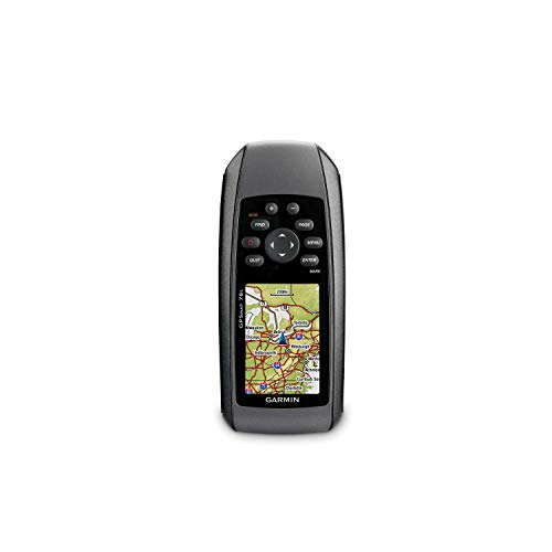
Best for: Budget-conscious mariners who want a compact, worldwide chartplotter with basic navigation features. The 78 offers a small footprint and straightforward operation for simple outings.
Why selected: Its compact form factor and worldwide basemap provide a solid baseline navigation option for casual day trips or as a backup unit on larger vessels.
Caution: Battery life and modern chart features are more limited than newer models; consider this as a secondary device for primary navigation.
C-MAP Reveal X US Lakes North East

Best for: Chartplotter owners who want detailed vector charts with high‑res bathymetry for lake navigation. The Reveal X series provides up-to-date hydrographic data and auto-routing features.
Why selected: It integrates comprehensive hydrographic information with optional Genesis data and a subscription-free autorouting feature, aiding efficient route planning on inland and coastal lake systems.
Caution: This card is chart-plotter dependent; ensure your device accepts the specified map card format and updates are available for your region.
Buying Guide: Key Purchase Considerations
- Navigation needs: Do you need floating handhelds for on-deck use or larger fixed chartplotters for a vessel’s console?
- Chart coverage: Are you navigating coastal waters, lakes, or worldwide routes? Look for BlueChart, HRB bathymetry, or vector charts that match your region.
- Communication features: Is satellite messaging or inReach integration important for remote trips?
- Memory and routing: Do you require extensive waypoint storage and auto-routing capabilities?
- Durability: Do you need IPX ratings, floating designs, or fogproof glass for harsh marine environments?
- Compatibility: Confirm that the map cards or preloaded charts are compatible with your existing devices and chartplotters.
Frequently Asked Questions
- What is a chartcard versus a handheld GPS?
– A chartcard contains chart data for a specific region or vessel system. A handheld GPS is a portable device that uses built-in or preloaded charts and can log waypoints and routes. - Do all these devices float?
– Several models in this list are designed to float and be water-resistant, which is ideal for open-water use. - Can I use these devices without internet access?
– Yes. Most handheld units work offline with preloaded charts and onboard basemaps, though some features may require satellite connectivity. - What is auto-routing on chartplotters?
– Auto-routing automatically plots a shortest or safest route based on chart data and vessel parameters. Availability depends on the card and device. - How important is bathymetry data?
– Bathymetry helps identify shallow areas and underwater topography, which is crucial for depth-aware navigation and fishing spots. - Are there subscription fees for charts or services?
– Some services and data layers require subscriptions, while others are included with preloaded charts or map cards.