Best Handheld Marine GPS With Maps for Clear Navigation Afloat
Direct answer: these handheld marine GPS devices provide preloaded charts, reliable satellite support, and rugged, floatable designs ideal for boaters, anglers, and coastal explorers. The top picks below are best for marine lovers who want reliable mapping, easy waypoint tracking, and durable performance in wet or salty environments. This guide highlights five options that balance chart quality, battery life, and rugged features. Use the buying guide to compare chart coverage, memory, and satellite support to match your boat size, planned routes, and typical water conditions.
Summary table of selected products
| Product | Best For | Key Feature | Notes |
|---|---|---|---|
| Garmin GPSMAP 79s | All-around mariners | Worldwide basemap; floats | High memory for many waypoints |
| Garmin GPSMAP 79sc | Coastal cruising | BlueChart g3 preloaded; floats | Excellent chart integration |
| Garmin GPSMAP 86Sci | Inreach users & data streaming | BlueChart preloaded; InReach capable | Advanced connectivity |
| Garmin GPSMAP 78 | River and coastal navigation | Marine navigator with worldwide chartplotter | Compact, simple |
| Garmin GPSMAP 65 | Remote locations | Multi-band GNSS | Strong satellite performance |
Garmin GPSMAP 79s Marine Handheld

The Garmin GPSMAP 79s is a rugged, floating handheld GPS designed for mariners who need worldwide coverage. Its high-resolution color display with fogproof glass supports multiple satellite constellations for reliable tracking around coastal waters and open seas. Best for boaters who want a durable, floatable unit with ample memory for numerous waypoints and routes.
Best for: Small to mid-sized boats needing a floatable, durable device with worldwide basemap. Why chosen: robust design, expanded memory for 10,000 waypoints and 250 routes, and multi-constellation support for global positioning. Caution: unit-level IPX6 water-resistance means submersion beyond that rating should be avoided.
Garmin GPSMAP 79sc Marine Handheld Preloaded With BlueChart g3

This GPSMAP 79sc comes preloaded with BlueChart g3 Coastal Charts and a rugged, floating design. It is ideal for coastal cruisers who want precise chart coverage and reliable navigation data, plus built-in compass and extra memory for a large waypoint and route library.
Best for: Coastal cruisers who value integrated BlueChart coverage. Why chosen: built-in compass and extended memory improve planning on tighter itineraries. Caution: still limited to unit-level IPX6 protection; avoid deep submersion beyond spec.
Garmin GPSMAP 86Sci Floating Handheld

The GPSMAP 86Sci is a floating handheld with a 3” sunlight-visible display. It streams data from compatible chartplotters and instruments, and ships with preloaded BlueChart G3 coastal charts. It’s best for sailors who want to integrate onboard data with a compact, waterproof unit.
Best for: Boat owners who need data streams from chartplotters and reliable coastal charts. Why chosen: ability to stream boat data to consolidate marine system information. Caution: more complex features may require familiarization for new users.
Garmin GPSMAP 78 Marine Navigator
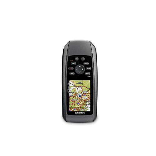
The GPSMAP 78 offers a compact marine navigation option with a worldwide chartplotter capability. It is suitable for boaters who prefer a smaller handheld unit while still requiring reliable mapping and basic navigation features. Best for: compact setup on small boats where space is at a premium. Caution: battery and memory options are more limited than larger models.
Garmin GPSMAP 65 Handheld

The GPSMAP 65 features expanded satellite support and multi-band technology in a compact form with a 2.6” color display. It includes routable TopoActive maps and a U.S. public land map, making it well-suited for coastal hikes or shoreline exploration where precise positioning matters in challenging terrain.
Best for: Mariners who also spend time ashore in challenging locations. Why chosen: multi-band GNSS improves accuracy in urban canyons and forested shores. Caution: slightly smaller display compared to larger models may affect readability underwater use in bright glare.
Buying Guide
- What charts are included? Look for BlueChart or marine basemaps for coastal navigation and chart compatibility with your region.
- What satellite systems are supported? Multi-GNSS (GPS, GLONASS, Beidou, Galileo, etc.) improves accuracy in challenging conditions.
- Is the device waterproof and floatable? For most saltwater use, floatability and IP ratings are crucial, especially if dropped.
- How much memory is available for waypoints and routes? Consider models with ample memory if you plan long trips with many stops.
- Can it connect to onboard equipment? Some models support data streaming from chartplotters or instruments for a unified marine system.
- Is the display readable in sunlight? A bright, high-contrast display reduces errors in direct sun.
Frequently Asked Questions
- What is a handheld marine GPS with maps best used for? It’s ideal for coastal cruising, fishing, and shore exploration where portable mapping helps plan routes and mark waypoints.
- Do these devices float? Many models are designed to float and resist water splash, but check IP ratings and user manuals for submersion limits.
- Can I use these devices to connect with on-board systems? Some models support data streaming from chartplotters, expanding your marine information network.
- What should I consider when choosing among models? Chart coverage, memory capacity, satellite support, and whether you need onboard data integration.
- Are there any limitations I should know? Some units have smaller displays or limited operation in extreme temperatures; verify suitability for your environment.
- Is a subscription required for updated charts? Some models include preloaded charts; additional updates may require subscriptions or downloads.