Best Handheld Marine GPS for Boats and Expeditions
Find the right handheld marine GPS for your next voyage or inland adventure. This guide focuses on rugged, floating devices with reliable satellite support, long battery life, and marine-ready features. Best fits include boaters who need floatable units, anglers seeking accurate waypoint tracking, and hikers who require multi-GNSS navigation on the water or shore.
Quick selection table
| Product | Key Strength | Best For |
|---|---|---|
| Garmin GPSMAP 79sc | BlueChart g3 coastal charts, rugged and floats | Coastal navigation and offshore trips |
| Garmin GPSMAP 79s | Worldwide basemap, robust durability, floats | Global excursions and harsh conditions |
| Garmin GPS 73 | SAILASSIST, long battery life | Sailing and coastal cruising |
| Garmin GPSMAP 86Sci | InReach capable, data streaming | Maritime data integration and messaging |
| Garmin eTrex 22x | Topo Active maps, rugged design | Outdoor adventures with detailed topo maps |
Garmin GPSMAP 79sc: Rugged, Floating Handheld

The Garmin GPSMAP 79sc is a floating, IPX6 water-resistant handheld with a high-resolution color display. It features BlueChart coastal charts, increased memory for up to 10,000 waypoints and 250 routes, and a built-in compass for quick orientation on deck. It supports multiple satellite constellations for reliable global tracking. Best for coastal explorers and boaters who need a rugged, buoyant unit that survives rough seas.
Who it’s best for: coastal travelers and anglers who require dependable navigation in wet environments. Why selected: its floating design and expanded waypoint capacity help you manage extensive coastal trips without fear of loss if dropped overboard. Caution: only unit-level IPX6 water resistance; ensure the device is kept away from full submersion in heavy spray.
Garmin GPSMAP 79s: Worldwide, Floating Master

The GPSMAP 79s offers a worldwide basemap and a rugged, floating design with a high-contrast display. It provides memory for up to 10,000 waypoints, up to 250 routes, and 300 fitness activities, with multi-constellation satellite support for reliable global navigation. Best for adventurous sailors and offshore travelers who need a dependable handheld in challenging conditions.
Who it’s best for: travelers who roam internationally and require a durable, water-tolerant device. Why selected: its global basemap and tough construction make it a strong all-around pick. Caution: while robust, on very deep submersion or extreme impact scenarios, a dedicated protective case is advised.
Garmin GPS 73: Sailor’s Companion
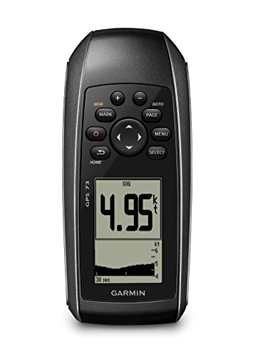
The GPS 73 emphasizes sailing features such as a virtual starting line, countdown timers, speed history, and tack assist. It also offers long battery life (18+ hours on 2 AA batteries) and marine-oriented alarms, route planning, and navigation options. Best for sailors who want race-ready cues on a compact handheld.
Who it’s best for: racing sailors and coastal cruisers who need sailing-specific tools. Why selected: SailAssist features help with timing and maneuver planning. Caution: uses AA batteries; consider spare batteries or a rechargeable option for longer trips.
Garmin GPSMAP 86Sci: InReach-Ready Crew

The GPSMAP 86Sci is a floating handheld with a 3” display, button operation, and preloaded BlueChart G3 coastal charts. It includes InReach satellite communication capabilities and data streaming from compatible chartplotters to consolidate marine information. Best for boaters who value satellite messaging and data integration on the water.
Who it’s best for: crews needing reliable communication alongside navigation. Why selected: InReach capability provides emergency connectivity and location sharing. Caution: data streaming features may require subscription services; confirm plan options before use.
Garmin eTrex 22x: Rugged Outdoors Navigator

The eTrex 22x delivers a 2.2” sunlight-readable display and preloaded Topo Active maps with routable roads and trails. It suits hikers and boaters who need reliable navigation on land and water alike, with a rugged build that handles challenging environments. Best for adventurers who require clear topo details and long battery life.
Who it’s best for: outdoor enthusiasts who mix land and water activities. Why selected: strong topo mapping and rugged design make it a versatile choice. Caution: smaller screen compared to some marine-focused devices; plan away from glare-prone routes for best visibility.
Buying Guide
Key considerations when choosing a handheld marine GPS
- Floating and water resistance: If you often drop devices overboard or face heavy spray, prioritize models advertised as floating and with rugged IP ratings.
- Maps and charts: BlueChart, Navionics data, Topo Active maps, and preloaded basemaps determine where you can navigate and how detailed the charts are. Consider whether you need coastal detail, offshore charts, or rugged topo layers.
- Battery life and power options: Look for devices with long runtime, plus the ability to use AA batteries or rechargeable packs for extended trips.
- Satellite support: Multi-GNSS (GPS, GLONASS, Beidou, Galileo, etc.) improves tracking in challenging conditions. InReach or satellite messaging adds safety options for remote routes.
- Navigation features: SAILASSIST, MOB alarms, route planning, waypoints, and tide data can influence your choice depending on sailing style and itinerary.
- Connectivity: Some models offer data streaming, wireless updates, and smartphone integration. Consider whether you need chartplotter data sharing with other devices.
- User interface and readability: A bright, high-contrast display with easy button controls helps in glare and wet conditions.
FAQ
- What is a handheld marine GPS best suited for?
Best for boaters and outdoor enthusiasts who need reliable navigation on or near water, with floating designs and marine-specific features.
- Do these devices require subscriptions for charts?
Some models include preloaded charts; others may require optional subscriptions for enhanced maps or satellite communication.
- Is a larger screen really better for marine use?
larger screens improve readability in bright sun and rough seas, but smaller devices are more portable and pocket-friendly.
- Should I pick a device with inReach or satellite messaging?
Choose InReach-enabled models if you need emergency messaging and GPS sharing in remote areas without cellular coverage.
- How important is battery life for long trips?
Very important. Look for models with extended runtime and alternate power sources to avoid mid-trip outages.
- Are multi-GNSS receivers worth it?
Yes, they improve position accuracy and reliability in challenging environments like canyons, tree cover, or open water.