Best GPS Units for Boats: Reliable Marine Navigation Devices for 2026
Answering the question, these GPS units for boats provide reliable navigation, coastal charts, and marine-specific features. They are best suited for boaters who want accurate wayfinding, chart plotting, and easier route planning. The top picks include handhelds for offshore adventures and fixed-chartplotters for on-deck use. Below is a quick summary to compare core capabilities.
| Product | Best For | Key Strength |
|---|---|---|
| Garmin GPSMAP 79sc | Offshore and coastal use | Floating, rugged, preloaded BlueChart g3 |
| Garmin GPSMAP 86Sci | Floating handheld with data streaming | InReach capability, bluechart preloads |
| Garmin ECHOMAP UHD2 94sv | Fixed chartplotter on boats | GT56 transducer, Navionics+ charts |
| Simrad GO9 XSE | Multifunction navigation and sonar | Includes Discover chart card, high-clarity display |
| Garmin GPS 73 | Compact handheld sailing and day cruising | Marine features, long battery life |
Garmin GPSMAP 79sc, Marine Handheld With BlueChart

Product overview: Rugged, floating handheld GPS with a high-resolution color display. It is water-resistant (IPX6 at unit level) and designed to float, aiding retrieval after a drop. Preloaded BlueChart coastal charts provide reliable marine navigation with expanded memory for waypoints and routes. It supports multiple satellite systems for global coverage.
- Best for: Coastal explorers and boaters who need a floating, durable handheld device for nearshore navigation.
- Why selected: Combines rugged design with floating capability and broad satellite compatibility for steady tracking on the water.
- Caution: Battery life and screen readability can vary in direct sun for extended long-use days.
Garmin 010-02256-00 eTrex 22x

Product overview: Rugged handheld GPS navigator with a 2.2” sunlight-readable color display. It comes preloaded with Topo Active maps featuring routable roads and trails, suitable for both cycling and hiking. While not a fixed marine unit, it serves as a dependable backup or primary handheld navigation option for smaller boats or onshore exploration.
- Best for: Boaters who want a versatile, rugged handheld with topo mapping for in-port navigation and dry-land use.
- Why selected: Lightweight and field-ready with clear display and routable maps for diverse activities.
- Caution: Not specifically optimized for marine charts; use alongside marine chartplotters for best water navigation.
Garmin – GPS/Nav System For Boats

Product overview: An in-boat navigation system featuring a crisp, sunlight-readable touch-screen and vivid color palettes. Built-in Navionics+ mapping provides reliable coastal coverage and chart detail for ocean and lake navigation. The display is designed to remain legible in bright outdoor light, helping with route planning and situational awareness on deck.
- Best for: Boats needing a bright, touch-screen navigation unit with integrated Navionics mapping.
- Why selected: Combines a user-friendly interface with comprehensive coastal chart data for planning and tracking.
- Caution: Depending on vessel size, mounting and power requirements should be considered for permanent installs.
Garmin ECHOMAP UHD2 94sv

Product overview: A 9″ touchscreen chartplotter with GT56 transducer for traditional, ClearVü, and SideVü sonar. Includes built-in Navionics+ coastal charts for an integrated navigation experience with high-detail marine mapping. This setup is suitable for more complex boat systems and precision sonar work.
- Best for: Larger boats and anglers who want advanced sonar and robust coastal charts in one unit.
- Why selected: Combines excellent visualization, sonar clarity, and comprehensive chart data in a single display.
- Caution: Higher complexity may require installation planning and transducer mounting considerations.
Simrad GO9 XSE Chartplotter

Product overview: Multifunction display that combines GPS navigation, sonar support, and optional radar. Includes a C-MAP DISCOVER chart card with vector charts, tides, currents, and Bathymetric contours for US and Canada. The bundled HDI transducer provides CHIRP sonar and DownScan Imaging for target identification.
- Best for: Sportboats and smaller cruisers needing an all-in-one navigation and sonar solution.
- Why selected: Strong feature set for navigation and fish targeting with robust chart data.
- Caution: System complexity may require careful installation planning and transducer placement.
Garmin GPS 73 Handheld
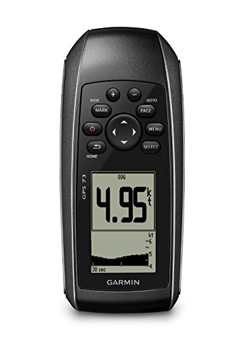
Product overview: Compact handheld with 2.6-inch display and a focus on marine features, including MOB, alarms, and tack assist. It provides long battery life on two AA batteries and supports route planning and essential navigation needs for on-the-water use and sailing.
- Best for: Sailors and day boaters seeking a compact, long-lasting handheld with marine features.
- Why selected: Small form factor with practical sailing aids and extended battery life for extended trips.
- Caution: Smaller screen may limit detailed chart viewing compared with larger chartplotters.
Buying Guide
Key purchase considerations for gps units for boats:
Frequently Asked Questions
- What should I consider when choosing a marine GPS?
– Consider the environment (coastal vs offshore), display size, chart coverage, and whether you need built-in sonar or networking with other devices. - Are handheld GPS devices suitable for boats?
– They work as backup or for small craft use, but fixed chartplotters provide more powerful navigation features and larger screens. - Do marine GPS units include maps by default?
– Many models come preloaded with coastal charts; some rely on add-on maps or subscriptions for full coverage. - Is a waterproof and floating unit important?
– Yes, for boating safety and convenience, especially for handheld devices used near or on water. - Can chartplotters integrate sonar data?
– Some models offer built-in sonar or can connect to transducers for CHIRP imaging and DownScan. - What is Navionics+ and why does it matter?
– Navionics+ provides detailed coastal charts and features that enhance route planning and fishing insights.